PHOTOSAm chilling out right now in exotic Kathmandu after an amazing 1000 kilometre adventure/challenge/holiday??!! cycling from Lhasa in Tibet to here in Kathmandu. We were at mostly over 12,000 feet and cycled over passes of almost 17,000 feet. We visited the Tibetan Everest Base Camp at the north face. We cycled the longest downhill in the world, and we survived the mad, bad and extremely dangerous Kathmandu traffic at the very end. An amazing three weeks and a fuller write-up and photos will follow. For now, here are the trip notes from the
Red Spokes website =
DAY 1 - Lhasa to the base of the Khamba La pass
MY REPORT
We left Lhasa in lovely sunny weather, stopping at the Potalla Palace for photos. We had a good few miles of busy city traffic before things calmed down a bit and the scenery improved. Lots of huge mountains all around, big blue rivers and lines of golden trees at the sides of the road. A lunch of rice and noodles in a field. Turned off onto a quiter road for the last 10km and got a puncture with 5km left. camp was at 3500 metres in amongst some trees.
DAY 1 PHOTOS80km; 3h 45m cycling; 130 metres ascent; 135 metres descent
Maximum Altitude: 3617m; Sleeping Altitude: 3608m
"We leave our hotel in convoy out of Lhasa, stopping outside the Potala Palace for a group photograph to mark the start our epic journey. Once outside Lhasa you have a chance to take advantage of the flat roads and go at your own pace, stretch your legs and get warmed up for the climbs to come! The route follows the deep green water of the Kyi Chu (Lhasa River), with hills forming a picturesque backdrop as we head towards Chusul. The road pulls away from the river as we pass the recently constructed bridge and tunnel to Lhasa airport and gain our first views of snow-capped mountains ahead. We stop for some lunch and then it’s on towards Daga where we cross onto the south bank of the Yarlung Tsangpo River; the highest major river in the world, with an average elevation of about 4000 meters. We follow the south bank some 10 km to our camp at the base of the Khamba La pass, with a short walk to the river to freshen up before dinner is served by our Nepalese cooks."DAY 2-Base of the Khamba La pass to Nakartse
MY REPORT
Started straight off with a massive big climb up to approx 4800 metres. Roads were great with nice gradients and lots of sweeping hairpin bends. After I hit the sunshine after 20 minutes the layers of clothes were peeled off down to shorts and T-shirts for this really enjoyable climb, seemingly feeling no great affects of the altitude. Amazing views from the col of a massive turquoise lake and the first of the snow-capped mountains. A quick col 1000 feet descent to lunch at a lovely sunny spot by the lake. A few of the party were suffering from the altitude here. After lunch we had an easy 2 hours alongside the stunning lake. Camp was beside another lovely lake at about 4500 metres. We enjoyed a ovely dinner of spicy veg soup, momos & chips and even banana pie. A great day out.
DAY 2 PHOTOS74km; 5 hrs cycling; 1225 metres ascent; 425 metres descent Maximum Altitude: 4807m; Sleeping Altitude: 4296m
"Today marks the first of our major climbs - 23 km to the Khamba La pass at 4807m. Recently laid tarmac aids our climb, but it will still be a tough day’s cycling as our bodies continue to adapt to the high altitudes. The reward for this morning’s challenging climb is the sight of the stunning, turquoise waters of the Yamdrok Tso (lake), this is a sacred lake to Buddhists. You will also be treated to the sight of the snow-capped Nazin Kang Sa (7252m) in the distance. We now make a fast descent (500 m) to the lake below and onto the Tibetan plateau. We will stop for lunch after about 5km, before completing the last 38 km into camp along flat but tough terrain."DAY 3-Nakartse to Lungmar
MY REPORT
A long straight boring patch of road to start the day. However, we then entered narrower , mountainous terrain with snow-capped mountains nearby. There was a long hard drag up to the col - Karo La (5032m). We had great views of a nearby glacier before enjoying a great sweeping descent on switchbacks. We camped beside a river with some locals making their mud bricks beside us.
DAY 3 PHOTOS52km; 3h 20m cycling; 600 metres ascent;520 metres descent
Maximum Altitude: 5032m; Sleeping Altitude: 4516m
"As we leave our camp today on the tarmac road we head west and climb to cross the Karo La pass (5032m). The first of the passes above 5000m, this is a challenging but enjoyable ride to the top of the pass, from where you will see an imposing glacier. Karo La is where Francis Younghusband fought a battle with Tibetans in 1903 to reach Lhasa." DAY 4-Lungmar to Gyantse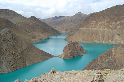
MY REPORT
Started the day off with a long chilly 20km downhill and then a couple of testing wee climbs to warm us up. There were amazing reservoirs of turquoise blue amidst rocky mountains. We then had a brilliant fast downhill section to lunch in the hot sun. It was in to shorts and T-shirt after lunch for a fast flat ride into Gyantse. In the afternoon we had a tour of their lovely monastery, though I was flagging a bit by then and tired and very hungry. We were surprised with a nice hotel for the night instead of camping, which was great.
DAY 4 PHOTOS60km; 2h 10m cycling; 255 metres ascent; 725 metres descent
Maximum Altitude: 4516m; Sleeping Altitude: 4048m
"Today begins with a gentle climb of 15km to the top of the Simi La followed by an easy ride of 35km, mostly downhill to Gyantse. The town is home to some magnificent military and religious sights dating back to the 15th C. The most famous of its monasteries is the Kumbum, a gold-topped pyramid barely touched by the passage of time and one of the most spectacular buildings in Tibet. You will be free this afternoon to enjoy looking around Gyantse."DAY 5-Gyantse to Shigatse
MY REPORT
A very flat sunny start to the day along the valley floor with dry rocky mountains all around. Bit of a headwind slowed things down and I felt a bit flat initially. Either side of the road were fields and fields of crops (barley?) being harvested by hand, tractor and yak. Ended the day in a lovely hotel in Shigatse and had pizza and chips at the restaurant for a treat.
95KM; 3h 45m cycling; 70 metres ascent; 225 metres descent;
Maximum Altitude: 4048m; Sleeping Altitude: 3852m
DAY 5 PHOTOS"A comfortable ride of 95 km on a nice tarmac road to Shigatse. As we follow the Nyang Chu River, we turn one corner after another along a series of bends in the road. Unusually for this trip we are on flat road all day."DAY 6-Shigatse to the base of the Tso La pass
MY REPORT
Another sunny day to start off with and not all that cold either and warmed up nicely after lunch. We were in convoy out of Shigatse and then on to wide quiet roads, not too flat but enjoyable. Scenery still in the barren rocky mountain style. We climbed a few smaller passes, more of a steady drag up especially into the headwind. We had a nice sunny campsite and enjoyed daal baht, veg and rice for tea, followed by lovely banana custard.
95km; 4hrs cycling; 645 metres ascent; 300 metres descent
Maximum Altitude: 4160m; Sleeping Altitude:4160m
DAY 6 PHOTOS"We leave Shigatse in convoy, climbing steadily up 125m in the first 8km at the start of a long day’s cycling. After some 35 km we cross the almost unnoticeable Tso La pass (4050m). The undulating terrain takes us past fields from where children will shout “Hello!” and run to see you if you stop to take a break. The surrounding mountains close in on us as we enter into a river valley before reaching our camp a short distance before the Tso La pass."DAY 7-Base of the Tso La pass to base of Gyatso La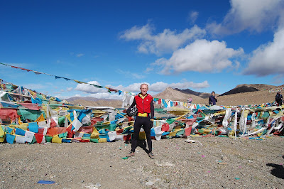
MY REPORT
A steady flat first 30 mins, then a good climb up to a proper Pass at 4580 metres, witht the usual surfeit of prayer flags everywhere and super views, felt quite strong. Amazing descent for miles and miles, steep at first then easing off and fast all the way to lunch. Wayne and Steve on the tandem hit 50mph!! Lunch was by a hot spring where all the local kids were out doing their washing. An hour after lunch took us to camp at the foot of another big climb, to be left for tomorrow. Nice pasties for tea, veg, potato mayo and chocolate pudding.
65km, 3hrs cycling; 535 metres ascent; 545 metres descent;
Maximum Altitude:4533m ; Sleeping Altitude 4145m
DAY 7 PHOTOS"A steady 8 km climb takes us to the Tso La pass (4580m), followed by a fast downhill descent of 425m over 29 km, and a flat stretch into Lhatse. Lhatse is reminiscent of a Wild West frontier town; children here are both friendly and inquisitive and not afraid to interact with us strangely dressed cyclists! We head out of Lhatse and into the Chusar Chu valley, where we camp at a very picturesque spot along the riverside."
DAY 8-Base of Gyatso La to Shregar
MY REPORT
An early start at 8.25am for the long climb up to the highest point of our trip - Gyatso La 5220 metres. Took it steady all the way and felt good. Was first to the top in 2hrs 30mins. It was surprisingly sunny and warm at the top as I waited for the others, taking in the fantastic views all around. There was then a windy descent for 10km down to lunch, followed by a long descent into the headwind, surrounded by more rocky barren terrain, to a nice camp beside a river. We enjoyed a nice sunny evening and had Daal, rice veg, garlic potatoes and chocolate custard for dinner. I won two games of Perudo in a row afterwards!!
66km; 4hrs cycling; 1100 metres ascent; 855 metres descent
Maximum Altitude: 5253m; Sleeping Altitude:4408 m
DAY 8 PHOTOS"The day starts with a 24km climb on sealed roads to the highest pass- the Gyatso La (5220m). Your reward is stunning views of the snow-capped mountains either side of the pass and the offer of a cup of Yak tea from the solitary tent alongside the fluttering prayer flags. We drop down 10km, out of the wind, to our lunch stop. The gradual descent takes through small villages and past Stupas down to the Lolo River. You may well be greeted by excited children from a roadside school at the foot of the descent, before you reach camp at a picturesque site next to the river."
Shregar to PaduA fast descent from camp takes us through a checkpoint and to the turn-off for the highlight of the tour: Everest! The early morning sun softens the rugged appearance of the landscape as the sun bathes the lightly snow-covered mountains around us. The terrain changes abruptly as we leave the main road towards Everest, making the switchback-climb to the top of the Pang La (5200m) a slow one. On a clear day you will get a just reward at the top of the pass- stunning views of the Himalayas, with Everest directly in front of you! A fast descent of never-ending switchbacks takes us through settlements where local people will often be grouped together in fields drinking Yak tea and making bricks. We drop further into an almost desert-like valley floor and onto camp surrounded by rugged mountains.
Maximum Altitude: 5205m
Sleeping Altitude: 4213m
Distance: 70.5km
Padu to RongbukWe take a gradual climb through villages where children will come and greet you and savour any photo opportunity and even a test-ride on your bike! Jagged snow-capped peaks confront us as we start our climb to Rongbuk. You will be seized by the anticipation of seeing Everest right in front of you as you turn every corner. The last few days are justly rewarded by the awe-inspiring backdrop of Everest on reaching our camp just beyond the monastery at Rongbuk.
Maximum Altitude: 5009m
Sleeping Altitude: 5009m
Distance: 40.1km
Rongbuk to Everest Base CampWe embark on the final leg to our closest point to Everest- Base Camp. This is a steady 8km ride taking us to the base of the North Face for a truly spiritual experience- simply unforgettable.
We return to Rongbuk for lunch and then back down the valley, retracing our tracks from the previous day. For the more technically minded riders there are some excellent sections of stony single track, with Everest as your backdrop! Faster smooth tracks wait at the bottom of the descent and the option for a couple of stream crossings as we turn left from our original path to our camp by the rivers edge.
Maximum Altitude: 5168m
Sleeping Altitude : 4350m
Distance 16.9km
Zamphuk to TingriToday brings us a superb off-road ride along smooth mountain tracks with the occasional rough sections that will provide a challenge even to our hardy support vehicles. With the Himalayas forming a backdrop this makes for another superb day’s cycling- cross-country mountain biking style. We reach a maximum altitude of 5101m before descending a mixture of rough sections mixed with free-flowing dirt tracks and stream crossings on into the barren plains ahead of Tingri, where we rejoin the Friendship Highway to our camp just outside the town. You will have the option of rewarding yourself for the last few days of hard cycling by visiting the local hot springs!
Maximum Altitude 5101m
Sleeping Altitude 4355m
Distance: 62.5km
Tingri to the base of the Lalung LaToday’s cycling is predominantly flat although headwinds may hamper the otherwise comfortable day! The ride will take us past monasteries, fortresses and along rivers of clear river mountain water. We will camp again by the riverside at the foot of our final climbing challenge- the double passes of Lalung La (5009m) and Yakri Shong La (5149m).
Maximum Altitude: 4563m
Sleeping Altitude: 4560m
Distance: 61.4km
Base of the Lalung La to NyalamToday starts with a long 12km drag to the Lalung La pass where we will gain views of Shishapangma before embarking on a superb descent before our second big climb of the day to the Thang La pass. The Thang La pass gives amazing views from within the midst of the Himalayas; a vivid reminder of the fact that you are crossing the world’s highest mountain range on our journey into Nepal. Mountain bikers will have a chance to sample some shortcuts between the numerous switchbacks on our descent to lunch. The challenge of the day is by no means over as we will have-to contend with strong headwinds over an undulating terrain. We are, however, starting our descent into Nepal and the change in vegetation will become noticeable as we reach our camp in the tight confines of a gorge with breathtaking drops, just beyond Nyalam.
Maximum Altitude: 5149m
Sleeping Altitude: 3775m
Distance: 84.4km
Nyalam to beyond KodariOn emerging from your tent you may well be greeted by mountains protruding the early morning cloud. Today is all about pure descent- on the world’s longest downhill ride, leaving the barren Tibetan Plateau behind and on into the lush scenery of the Nepalese jungle. The descent will take you over bridges and through stream crossings from the many waterfalls carrying water off the mountain walls, which you will never stray far from, steep drops on the opposite side of the road. As we reach the border town of Zangmu the surroundings will change suddenly as you come to long lines of trucks awaiting passage into Nepal. This is where we leave behind our Tibetan staff and enter into ‘no man’s land’- a 7km descent to the Nepalese border town of Kodari. We stop for lunch in Kodari and finish the day with a very relaxing ride through the Nepalese countryside, greeted by local children. Our final camp is by the riverside, a waterfall and rock pool providing a natural shower and bath to clean-up before tonight’s party! It is customary for the Nepalese guides to celebrate their return to Nepal by throwing a party, often joined by locals from surrounding settlements- a truly memorable cultural exchange.
Maximum Altitude: 3776m
Sleeping Altitude: 1065m
Distance: 69km
Beyond Kodari to DhulikelToday starts with an undulating ride through small villages, with inquisitive locals and picturesque views of the tree-covered mountainsides, peppered with houses. The weather is noticeably warmer now and will replace the altitudes of Tibet as we face the challenge of the 25km climb (904m) into Dhulikel. We will make a stop for lunch after 10km. We stay in a beautiful mountain lodge where it may be possible to discern the Himalayan mountain range if the mist is not too dense.
Maximum Altitude: 1535m
Sleeping Altitude: 1535m
Distance: 64km
Dhulikel to KathmanduOur final day’s cycling takes us from Dhulikel to Kathmandu, our starting point 3 weeks ago. We will pass school children on their way to school and the roads will become increasingly more hectic as we approach Kathmandu; you will need your wits about you, at the same time as trying to absorb the spectacle of early-morning life all around you. We group up close together in convoy, following our support vehicle on the outskirts of Kathmandu and cycle all the way to our original hotel. Once at the hotel we will pack up the bikes and have lunch, leaving the rest of the afternoon to revisit Kathmandu and do some shopping. In the evening we will get together for that all important and well-deserved celebratory meal!
Maximum Altitude: 1535m
Sleeping Altitude: 1314m
Distance: 32km


